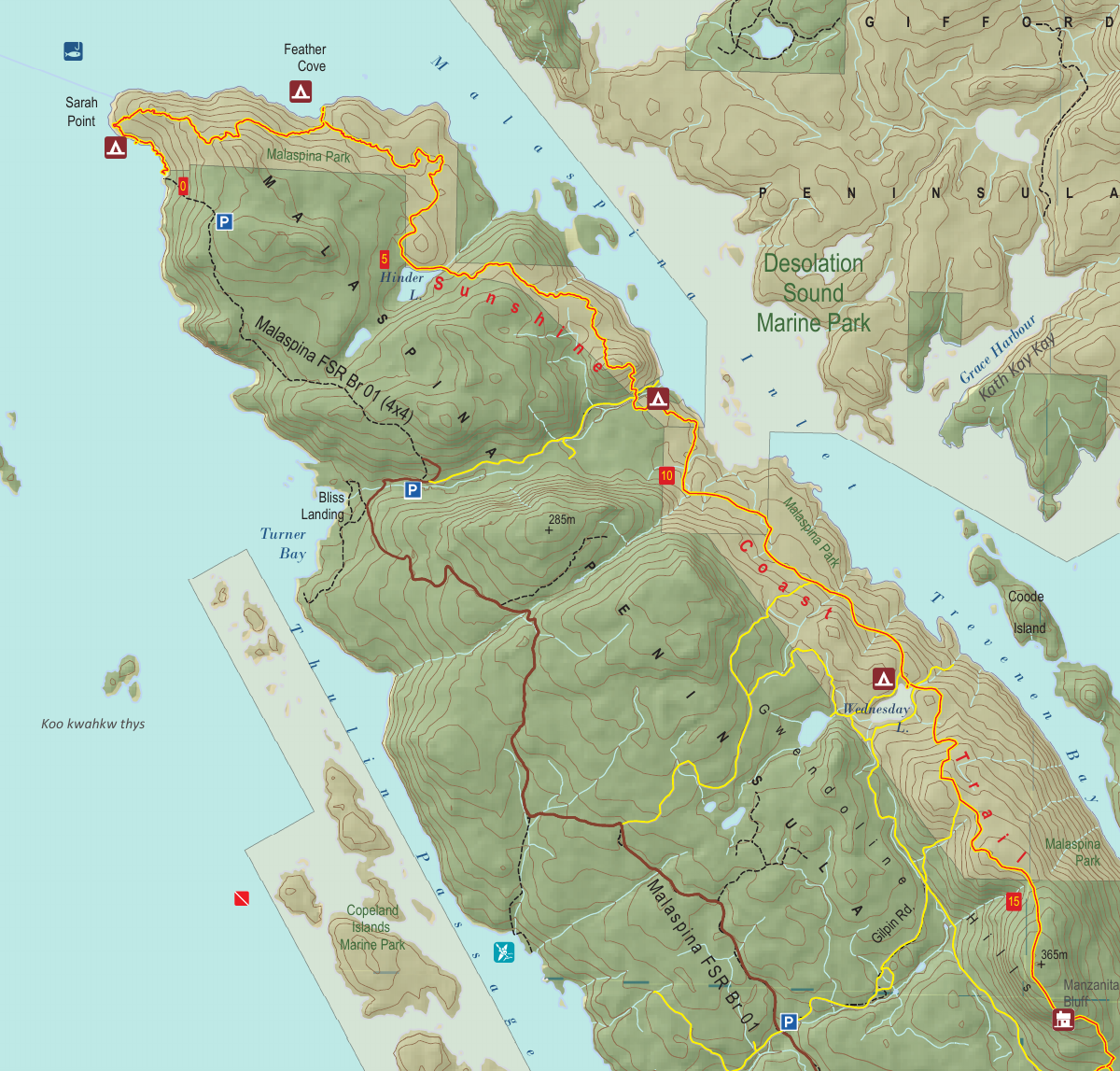
Section 1: Lands End & Gwendoline Hills
Manzanita Hut
Kilometre 16
Sleeps 10
5 Facilities
About This Hut
Manzanita Hut sits high on Manzanita Bluffs, offering one of the most scenic locations on the Sunshine Coast Trail. This semi-enclosed shelter features large glass windows in the cooking area, allowing hikers to enjoy panoramic views of the Salish Sea while preparing meals. The hut is surrounded by beautiful manzanita bushes, arbutus trees, and old-growth Douglas fir. It's also an excellent spot for eagle watching and makes a great lunchtime destination for day hikers.
Key Features
- •Panoramic views of Copeland Islands, Savary Island, and Salish Sea
- •Large glass windows for scenic meal preparation
- •Surrounded by arbutus trees and old-growth Douglas fir
- •Excellent eagle spotting location
- •1.5-2 hours from either end of Gwendoline Hills Trail
- •Very popular destination - arrive early
How to Get There
- 1From Bliss Portage Hut, continue south on the SCT for 8 km
- 2Hike through forested sections and climb to Manzanita Bluffs
- 3Follow red trail markers to the hut
- 4Alternative access: Drive from Powell River toward Sarah Point
- 5About 2.3 km past Lund, turn right onto Rowe Road (Malaspina FSR 6106 Br.02)
- 6Park here unless you have 4×4 vehicle
- 7Follow FSR 6106 Br.02 southward for 2 km to triangle junction
- 8Take left fork and hike 1 km to Spire Trail
- 9Follow Spire Trail uphill to the right
- 10At SCT/Spire Junction (edge of 2010 cutblock), turn left
- 11Hike 1 km up to Manzanita Hut
Trail Map
Click the map image below to download the complete section map PDF with detailed trail routes, elevation profiles, and landmarks.
Download Full Map
Quick Info
Location
Kilometre 16
Capacity
10 people
Trail Section
Section 1
Lands End & Gwendoline Hills
Facilities
- Outhouse
- Picnic tables
- Food cache
- Fire pit
- Sleeping loft
Water Source
None at hut. Collect water at Thulin Springs (500m away, northbound) or Wednesday Creek (12.2 km mark, southbound)